
|

|

|

|

|

|

|

|

|
|
|
|
|
|
|
|
|
|
|
 Header.jpg)
|
Heading East |


|
|
The e-books There are custom colour maps, much more detailed directions and stories, charming illustrations and much more in the Highway One Travel Companion e-books. If you'd like to explore deeper into Highway One's attractions, and maybe do a little "highway archaeology" on Old Highway One then you may be interested in getting some of my in-depth e-books to be your travel companions. The introductory volume is free (at Smashwords) and the others are great value at only US$1.99 to US$2.99 each. You can find them at Amazon or Smashwords or use the links below to access them direct.
Click the links below to read more or download: |
  |
| Melbourne CBD | ||
 Full.jpg)
Busy traffic in Melbourne CBD (Elizabeth St). |
 Full.jpg)
Melbourne's iconic Flinders St train station. |
 Full.jpg)
With almost 1,000 traders in a 17acre site, Queen Victoria Markets is one of the largest open air markets in the southern hemisphere. |
 Full.jpg)
Busy St Kilda Rd is Old Highway One and the start of the delightful journey toward Gippsland and beyond from historic Princes Bridge. St Kilda Rd now carries the SR3 badge. |
 Full.jpg)
St Kilda Rd is a leafy introduction to Old Highway One. |
 Full.jpg)
From St Kilda Rd Old Highway One turns onto Dandenong Rd for the drive out of Melbourne and regains its famous National Route 1 badge! |
| Windsor | ||
 Full.jpg)
The 1930s art deco Astor Theatre is a highlight in Windsor. |
 (30 Jan 2011) Full.jpg)
Along Dandenong Rd in Windsor look out for 1873 Presentation College. |
|
| Prahran | ||
 (30 Jan 2011) Full.jpg)
Historic Chapel St crosses Old Highway One in Windsor; it's worth following it north for a few blocks. Among other notable old emporium buildings, look for Maples (corner Chapel & High Streets, it traded from 1904-87). |
 (30 Jan 2011) Full.jpg)
At 259 High Street in Prahran the still-functioning 1915 Prahran Mechanics Institute boasts a respected local history library. |
 Full.jpg)
Conway's Building graces a Chapel St corner. |
 Full.jpg)
This ornate Chapel St building now houses a pet store. |
 (30 Jan 2011) Full.jpg)
Prahran's St Matthews Anglican Church dates back to 1877. |
|
| Malvern | ||
 (4 Feb 2010) Full.jpg)
A vintage NR1 sign at Malvern reassures us we're on Old Highway One. |
 Full.jpg)
Old Highway One (Dandenong Rd) and the tram lines part company in Malvern. |
|
| Mulgrave | ||
 (30 Jan 2011) Full.jpg)
Another NR1 sign further east at Mulgrave. |
||
| Hallam | ||
 (30 Jan 2011) Full.jpg)
Historic Hallam Hotel was first built in 1872. |
||
| Berwick | ||
 Full.jpg)
Welcome to the City of Casey as Old Highway One changes designation from ALT1 to C101. Named after the town in northern England, Berwick (pop. 36,419) dates back to 1854. High St through Berwick is lined with poplar trees planted after WWI in honour of the fallen as well as historic buildings including 1857 Berwick Inn (once served as a coach stop for Gippsland travellers) and the 1862 Mechanics Institute and Free Library. |
||
| Tynong North | ||
 Full.jpg)
Just north of the M1 in Tynong look out for Gumbuya Park, originally a pheasant farm that was converted into a wildlife park in 1978 and also features rides, artefact displays and other attractions. The first of the Highway One "Giants", the Big Pheasant, is located here. |
 Full.jpg)
It's not usually so easy to find Old Highway One remnants! |
 Full.jpg)
A short section of Old Highway One linking between the Big Pheasant and Garfield Rd remains mainly to serve as a rest area. |
| Longwarry North | ||
 Full.jpg)
"Warragul Loop" Former Alignment - Old Highway One used to wander north of the current M1 here (bypassed in 1994) and take a scenic loop south and then east through pretty West Gippsland countryside and the small scenic towns of Drouin and Warrigal (bypassed 1985) - exit the freeway, relax, slow down and enjoy some vintage Old Highway One! |
 Full.jpg)
When Old Highway One sections are bypassed by new alignments/freeways the old signs are usually removed. In this case, however, a couple have been overlooked - this is gold!! |
 Full.jpg)
Interestingly, Old Highway One also used to head west for about 1�km from the Sands Rd T-junction back towards Melbourne, but now enters private land after about a kilometre in that direction (it's worth the short detour to see the old highway disappearing through a private property gate). |
| Robin Hood | ||
 Full.jpg)
Another classic NR1 remnant sign just near the Robin Hood Inn. |
 (5 Feb 2010) Full.jpg)
The Robin Hood Inn dates back to around 1870 and was once a major Cobb & Co stage-coach stop. |
|
| Drouin | ||
 Full.jpg)
Founded around 1870, Drouin (pop. 7,523) is an important commercial centre for the surrounding rich agricultural country. Prettily set on a ridge, it's an iconic, thriving West Gippsland town bypassed by the M1 in 1981. The annual Ficifolia (a red-flowering variety of Eucalyptus) Festival in February is a great time to visit and see the streets lined with trees in full flower (although the blooms can last for some months). |
 Full.jpg)
Christ Church Anglican Church was built in 1936 to replace the 1875 original timber church, which remains in use at nearby Buln Buln. |
 Full.jpg)
A monument to W Calder, a roads pioneer in Victoria, is just east of Drouin, |
| Warragul | ||
 Full.jpg)
Also on the Gourmet Deli Trail, Drouin's close neighbour Warragul (pop. 12,943) was settled in the 1870s as a camp site for railway workers. Like Drouin, Warragul is a major commercial centre for the surrounding rolling farmland, with milk supplied to Melbourne as a major industry. Queen St is vintage old Highway One in Warragul. It is lined with ornate, photogenic and historic buildings including the Historical Society located in the old 1892 Shire Hall. |
 Full.jpg)
The ornate Railway Hotel graces Old Highway One in Warragul. |
 and Hamburger Lunch (30 Jan 2011) Full.jpg)
Bangers & Mash and Hamburger Lunches were as good as they looked at the Railway Hotel in Warragul! |
 (30 Jan 2011) Full.jpg)
The 1912 Commercial Hotel is also right on Old Highway One in Warragul. |
||
| Yarragon | ||
 Full.jpg)
Yarragon (pop. 1,131) (once named Waterloo (see Trafalgar below!!)) is a major highlight on the Gourmet Deli Trail, featuring arts and crafts, antiques, galleries and cafes. In town, look for the steam train exhibit and the green calm of the gardens around the war memorial and the rotunda. The Commercial Hotel calls out to hungry travelers! |
 Full.jpg)
Busy Main St in Yarragon. |
 Full.jpg)
Lush green gardens provide a buffer between Yarragon and the M1 on its doorstep. |
 Full.jpg)
1916 former Presbyterian Church now operates as an antique store. |
 Full.jpg)
A comfortable residence in Yarragon's back streets. |
 Full.jpg)
A nice timber Yarragon country residence. |
 Full.jpg)
St Jarlath Catholic Church in Yarragon really catches the eye with its architecture. |
||
| Trafalgar | ||
 Full.jpg)
Trafalgar (pop. 2,686) is another charming Gippsland town, mainly a service town for the surrounding farming area. The Hotel Criterion is another great Gippsland pub. |
 (6 Feb 2010) Full.jpg)
The Trafalgar Public Hall started life in the 1930s as the Ideal Picture Theatre. |
 Full.jpg)
St Marys Anglican Church is a substantial building for a small town. |
| Moe | ||
 Full.jpg)
Old Highway One through Moe, now badged C103, was bypassed in 1967. It once connected with the even older Haunted Hills alignment further east. Settled in the 1850s, Moe (pop. 8,745) is another business and service hub for rich West Gippsland. Set prettily
in the Latrobe Valley, Moe offers ready access to nearby National Parks rich with wildlife. Originally established north of its present location, the town moved 3km south when the railway arrived in the 1870s. |
 Full.jpg)
You don't see an abandoned KFC every day! |
 Full.jpg)
At the west end of C103 is the former Lions Hotel Motel complex, now abandoned. It looked to be quite the big business in its day. |
| Haunted Hills | ||
 Full.jpg)
"Haunted Hills" Former Alignment - The locality of Hernes Oak (pop. 159) was once known as Haunted Hills and the old name lives on in the name of an excellent piece of Old Highway One (bypassed back in 1960) and in the name of the range of hills nearby. The old
road originally continued east from Hernes Oak through what is now the Yallourn Open Cut Mine before entering Morwell. The remaining road is classic 50-year-old Highway One; charming country road winding first through suburbia and then through pretty undulating
Gippsland countryside. |
||
| Traralgon | ||
 (30 Jan 2011) Full.jpg)
Settled in the 1840s, Traralgon (pop. 21,689) is the Latrobe Valley's largest town. Highlights for tourists include the wide tree-lined streets, gardens and parklands and the al fresco dining at the many cafes, restaurants, pubs and clubs. Newman Park in Peterkin St is a mecca for children with trains, rides and play equipment of all kinds. Most of the historic buildings here are on Franklin St. The Post Office and Courthouse complex dates back to the 1880s. |
 (30 Jan 2011) Full.jpg)
Traralgon's imposing Ryan's Hotel dates back to 1914. |
 (1914) (30 Jan 2011) Full.jpg)
This stately 1914 former church has found a new life as a restaurant in Traralgon. |
 Full.jpg)
The explorer Strzelecki is remembered in this memorial near Traralgon. |
||
| Rosedale | ||
 Full.jpg)
Rosedale (pop. 1,487) was once a staging post on the Port Albert to Sale coach route. It grew to be the seat for the former Shire of Rosedale before being absorbed into the modern Wellington Shire. The 1863 Rosedale Mechanics Institute is a highlight. |
 Full.jpg)
Rosedale's 1874 St Mark's Anglican Church. |
 Full.jpg)
The Rosedale Hotel has an art deco air. |
 Full.jpg)
This sagging roof looks in Rosedale like it's reaching the point of no return! |
 Full.jpg)
St Rose of Lima Catholic Church in Rosedale. |
 Full.jpg)
The Rosedale Tavern is right on the big A1 interesection in downtown Rosedale. |
 Full.jpg)
Rosedale's St Andrews Uniting Church is yet another substantial brick building. |
||
| Sale | ||
 Full.jpg)
Located in central Gippsland, Sale (pop. 13,336) is the scenic and historic gateway to East Gippsland, the Gippsland Lakes, 90 Mile Beach and much else. Originally named Flooding Creek when settled by the British in 1840, it was renamed Sale in 1850 after a prominent General. The inland Port of Sale first opened to shipping in 1890 and the opening of the Sale canal in 1898 established Sale as a busy port for coastal steamers. The Sale Court House is just one of the imposing heritage buildings all through town. |
 Full.jpg)
The old Cobb & Co coach stables in Raymond St date back to the 1870s. It's not often that timber buildings survive so long! |
 (6 Feb 2010) Full.jpg)
Stylish 1879 building in downtown Sale. |
 (6 Feb 2010) Full.jpg)
Sale's 1883 St Paul's Anglican Cathedral (fronting a lovely historic park). |
 Full.jpg)
Lovely old water tower in the park opposite St Paul's Anglican Cathedral in Sale. |
 Full.jpg)
1887 St Mary's Catholic Cathedral in Sale has been recently renovated. |
 2 (7 Feb 2010) Full.jpg)
Sale's historic swing bridge 5km south of town was built in 1883 to allow shipping to navigate the canal linking Sale to the Latrobe River and Lake Wellington - the bridge is still opened every weekend. |
 Full.jpg)
A beautiful heritage building in Sale. |
 Full.jpg)
The Star Hotel in Sale. |
 Full.jpg)
The Sale Hotel. |
 Full.jpg)
The abandoned Criterion Hotel in Sale. |
 Full.jpg)
This memorial to the explorer Angus McMillan is right on the big A1 roundabout in Sale. |
 (6 Feb 2010) Full.jpg)
This former Baptist Church (1901) was recycled as a business but is now empty again. |
 Full.jpg)
The Gippsland Times in Sale was established way back in 1860. |
 Full.jpg)
Sale Historical Museum occupies a stylish 1863 colonial building and houses a collection of paintings, photographs, fabrics and artefacts relating to the early days of the Gippsland area. |
 Full.jpg)
Look for Riverview Rd, a fast-weathering Old Highway One alignment parallel to and just north of the current highway east and west of the Thomson River crossing in the western outskirts of Sale. |
 Full.jpg)
A fascinating old shop in downtown Sale. |
 (6 Feb 2010) Full.jpg)
This classic 1874 old shop in Sale has had an ugly modern facade added but at least it's still with us! |
 (30 Jan 2011) Full.jpg)
The 1864 Sale Powder Magazine features a floor fixed in place with timber dowels to reduce the risk of explosions. |
||
| Stratford | ||
 Full.jpg)
While there is some uncertainty regarding the exact origin of its name, the more romantic-minded of us choose to believe that Stratford (pop. 1,949) is named for the English Stratford-on-Avon, birthplace of William Shakespeare. Stratford is highly "strollable" and has more
than its share of historic buildings.
|
 Full.jpg)
Old Highway One used to follow a different path across the Avon River into Stratford. Look for the old alignment 500m west of the Avon River on the north side of the Princes Highway. |
 Full.jpg)
Some old timber bridge pylons remain from the old bridge, heavily damaged by severe flooding in 1950 and replaced by temporary bridging until the current bridge opened in the mid-1960s. |
 Full.jpg)
The Avon Hotel in Stratford. |
 Full.jpg)
Stratford's monument to the explorer Angus McMillan. |
 Full.jpg)
Stratford's former National Australia Bank is now Hobbies Plus - be sure to drop in and say hello to Darren! |
 (31 Jan 2011) Full.jpg)
1868 Holy Trinity Anglican Church in Stratford. |
 Full.jpg)
The 1882 Mechanics Institute is the site of the Stratford Shakespeare Festival. |
 Full.jpg)
A nice mural in Stratford. |
 Full.jpg)
The old Avon Shire Council Chambers have been converted into what must be an interesting residence. |
 Full.jpg)
The old Stratford Court House now serves as a theatre and gallery. |
 (7 Feb 2010) Full.jpg)
Highway One is Stratford's main street. |
 Full.jpg)
Stratford's St Patricks Catholic Church. |
||
| Bairnsdale | ||
 Full.jpg)
Pretty Bairnsdale (pop. 11,282) is another important regional centre and jumping-off point for the East Gippsland tourist attractions and yet somehow still feels like a big, laid-back country town. The drive down Main St is particularly attractive.
|
 Full.jpg)
The fantastic murals in Bairnsdale's St Mary's Catholic Church. |
 Full.jpg)
Stylish and historic bandstand in the road-median parklands in Bairnsdale. |
 Full.jpg)
The striking and intricate 1894 Courthouse alone is worth the drive to Bairnsdale. |
 Full.jpg)
Bairnsdale's Commercial Hotel. |
 (7 Feb 2010) Full.jpg)
The former Albion Hotel in Bairnsdale has been nicely restored. |
 (1885) (31 Jan 2011) Full.jpg)
Bairnsdale's former St Andrew's Uniting Church operated as a Fish & Chips shop but seems to be unoccupied again. |
 (31 Jan 2011) Full.jpg)
The 1889 Grand Terminus Hotel at 98 McLeod St is a classic of Australian pub architecture. |
 (7 Feb 2010) Full.jpg)
The Bairnsdale Library dates back to 1889. |
 Full.jpg)
This stylish Salesian residence graces one of Bairnsdale's back streets. |
||
| Lakes Entrance | ||
 Full.jpg)
Situated on a man-made channel linking Bass Strait with the Gippsland Lakes, Lakes Entrance was originally a fishing village. |
 Full.jpg)
The Lakes Entrance History Centre & Museum is housed in the historic former Johnsonville Schoolhouse |
|
| Toorloo Arm | ||
 Full.jpg)
Old Highway One at Toorloo Arm is a real backwoods drive. |
 Full.jpg)
Road history on Old Highway One at Toorloo Arm. |
|
| Nowa Nowa | ||
 Full.jpg)
Nowa Nowa (pop. 144) was a timber town relying on local mills for income, however, there is currently only one mill still operating. Tourism has filled the void and Nowa Nowa now offers a range of outdoor activities, including cycling, fishing and other aquatic activities.
The East Gippsland Rail Trail passes just north of town. |
||
| Tostaree | ||
 abandoned road 4 (8 Feb 2010) Full.jpg)
"Woodlands Walk" Former and Abandoned Alignments - is one of the most charming abandoned old Highway One alignments. West of Hospital Creek is Jonsons Rd (bypassed in the 1960s) - enjoy a peaceful woodland stroll of less than 300m along the ghost of the
old road through a cutting and down to the site of an old bridge. The road used to continue across the bridge and on to the Old Princes Highway section to the north-east.
|
 Full.jpg)
I was lucky to be escorted by Bobby, the Tostaree Cottages' dog; maybe he'll go for a walk with you too. |
 Full.jpg)
The abandoned road is still sealed and the old centre line markings are still clearly visible. |
| Wombat Creek | ||
 (8 Feb 2010) Full.jpg)
A dusty Old Highway One remnant near Wombat Creek. |
||
| Simpsons Creek | ||
 Full.jpg)
"Ghost Railway Crossing" Abandoned Alignment west of Newmerella is an interesting abandoned alignment of over 1.7km. Both ends of the old road can be accessed. The old road here used to run north of the current A1 alignment and just south of the (also abandoned) old railway, which is now the East Gippsland Rail Trail. A highlight is the "Rail Crossing" warning painted on the road (look for it among the leaf litter on the abandoned road surface); there is something poignant about a warning for an abandoned railway crossing on an abandoned road. |
 Full.jpg)
The centre section of the "Ghost Railway Crossing" Abandoned Alignment west of Newmerella is overgrown and blocked by fallen trees. |
|
| Newmerella | ||
 Full.jpg)
The old road used to follow Burns Rd and Orbost Rd before crossing the Snowy River via a former bridge. Check out the view from the lookout down onto the Snowy River flood plain and the amazing old elevated railway trestles - that's both Old Highway One and the modern A1 Princes Highway down there. |
||
| Orbost | ||
 Full.jpg)
Old Highway One passes right through town. Orbost (pop. 2,452) is the major town hereabouts and has grown from a cattle run established in the 1840s. Bypassed in 1977, it's a service centre for the surrounding primary producers and also a great staging point for the national parks and coastal attractions nearby. |
 Full.jpg)
Interesting Marshalls Commonwealth Hotel is situated right on the Nicholson St/Salisbury St roundabout. |
 Full.jpg)
Yes, Marshalls Commonwealth Hotel Roast Lamb lunch in Orbost IS as good as it looks! |
 Full.jpg)
The Orbost Club Hotel looks like another good dining option in town. |
 Full.jpg)
Orbost is right on the banks of the legendary Snowy River. |
 Full.jpg)
St James' Anglican Church in Browning St dates back to the early 1900s and features interesting, if sombre, architecture! |
 former motel (9 Feb 2010) Full.jpg)
This former motel appears to be being converted into private apartments. |
||
| Cabbage Tree Creek | ||
 Full.jpg)
The tiny settlement of Cabbage Tree Creek is known as a birdwatchers' haven and provides a great base to explore the surrounding temperate rainforest - there's a little bit of "Old Princes Highway" to find too! |
||
| McKenzie River Rainforest Walk | ||
 Full.jpg)
This relaxing rainforest walk is recommended for a cool break from driving for a while. |
 Full.jpg)
|
 Full.jpg)
|
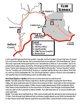
| Club Terrace | ||
 Full.jpg)
A dirt road Old Highway One loop used to meander north of modern Princes Highway to serve the small town of Club Terrace, bypassed in 1959. The highway bypass plus the cessation of the local mining and timber industries and closure of the local mills were the final nails for Club Terrace, once a busy small town; the abandoned Post Office is a remaining trace of the town. |
 Full.jpg)
Old Highway One srosses C616 Combienbar Rd in Club Terrace. |
|
| Cann River | ||
 Full.jpg)
Cann River (pop. 223) is a small service centre and timber town and is the perfect jumping-off point for Croajingolong, Alfred and other nearby National Parks. The Drummer Rainforest Walk is nearby too. The Cann River Hotel makes a great base in town. |
 Full.jpg)
A nice mural in Cann River - and yes it was good! |
 Full.jpg)
Cann River's St John the Evangelist Anglican & Uniting Cooperation Church is a timber beauty! |
| Wingan River | ||
 - Old H1 segment 2 (9 Feb 2010) Full.jpg)
There's a classic hidden Old Highway One remnant near Wingan River. |
||
| Genoa | ||
 Full.jpg)
Genoa was bypassed in 1989. Old Highway One used to cross the Genoa River on the now closed old 1920s timber bridge. |
 eastern approach (10 Feb 2010) Full.jpg)
Genoa's Old Highway One bridge (1928) eastern approaches. |
 timber decking (9 Feb 2010) Full.jpg)
The now closed Old Highway One 1920s timber bridge in Genoa. |
 Full.jpg)
A long abandoned farmhouse in Genoa. |
 Full.jpg)
A closed down business in Genoa. |
 Full.jpg)
The closed down General Store in Genoa. |
 Full.jpg)
The Genoa Hotel offers great meals and basic accommodation. |
 Full.jpg)
Here be dragons! A water dragon at nearby Genoa Falls. |
|
| Maramingo Creek | ||
 Full.jpg)
Modern Highway One winds through nice bushland near Maramingo Creek; not far to the NSW border now. |
 4 (10 Feb 2010) Full.jpg)
Sandy Waterhole Rd is an Old Highway One alignment near Maramingo Creek. |
 (10 Feb 2010) Full.jpg)
But becomes very overgrown very quickly. |

|

|
|
|